North Atlantic Basin-Scale Multi-Criteria Assessment Database to Inform Effective Management and Protection of Vulnerable Marine Ecosystems
 Telmo Morato1,2*
  Christopher K. Pham1,2
  Laurence Fauconnet1,2 Gerald H. Taranto1,2
  Giovanni Chimienti3,4
  Erik Cordes5
  Carlos Dominguez-Carrió1,2
  Pablo Durán Muñoz6
  Hronn Egilsdottir7
  José-Manuel González-Irusta1,2,8
  Anthony Grehan9
  Dierk Hebbeln10
  Lea-Anne Henry11
  Georgios Kazanidis11
  Ellen Kenchington12
  Lenaick Menot13
  Tina N. Molodtsova14
  Covadonga Orejas15
  Berta Ramiro-Sánchez11,16 Manuela Ramos1,2
  J. Murray Roberts11
  Luís Rodrigues1,2 Steve W. Ross17
  José L. Rueda18
  Mar Sacau6
  David Stirling19
  Marina Carreiro-Silva1,2
- 1Okeanos Research Centre, Departamento de Oceanografia e Pescas, Universidade dos Açores, Horta, Portugal
- 2Departamento de Oceanografia e Pescas, Instituto Do Mar, Universidade dos Açores, Horta, Portugal
- 3Department of Biology, University of Bari Aldo Moro, Bari, Italy
- 4Consorzio Nazionale Interuniversitario per le Scienze del Mare, Rome, Italy
- 5Department of Biology, Temple University, Philadelphia, PA, United States
- 6Centro Oceanográfico de Vigo, Instituto Español de Oceanografía, Vigo, Spain
- 7Marine and Freshwater Research Institute, Hafnarfjörõur, Iceland
- 8Centro Oceanográfico de Santander, Instituto Español de Oceanografía, Santander, Spain
- 9Earth and Ocean Sciences, National University of Ireland Galway, Galway, Ireland
- 10MARUM - Center for Marine Environmental Sciences, University of Bremen, Bremen, Germany
- 11School of GeoSciences, Grant Institute, University of Edinburgh, Edinburgh, United Kingdom
- 12Bedford Institute of Oceanography, Fisheries and Oceans Canada, Dartmouth, NS, Canada
- 13L'Institut Français de Recherche pour l'Exploitation de la Mer, EEP/LEP, Centre de Bretagne, Plouzané, France
- 14P.P. Shirshov Institute of Oceanology Russian Academy of Sciences, Moscow, Russia
- 15Centro Oceanográfico de Baleares, Instituto Español de Oceanografía, Palma, Spain
- 16Lab. Biologie des Organismes et Ecosystèmes Aquatiques (BOREA), Centre National de la Recherche Scientifique, Muséum National d'Histoire Naturelle, Institut de Recherche pour le Developpement, Sorbonne Université, Université de Caen Normandie, Université des Antilles, Paris, France
- 17Center for Marine Science, University of North Carolina at Wilmington, Wilmington, NC, United States
- 18Centro Oceanográfico de Málaga, Instituto Español de Oceanografía, Málaga, Spain
- 19Marine Laboratory, Marine Scotland Science, Aberdeen, United Kingdom
Introduction
The identification of areas that fit the Food and Agriculture Organization of the United Nations (FAO) criteria to define what constitutes a Vulnerable Marine Ecosystem (VME) has been the main policy driver for the protection of deep-sea environments in Areas Beyond National Jurisdictions (United Nations General Assembly, 2006; FAO, 2009) in relation to bottom fisheries. At the same time, the Convention on Biological Diversity advocates for the implementation of representative networks of Marine Protected Areas (MPAs) in the open ocean and the deep sea, and calls for the identification of Ecologically or Biologically Significant marine Areas (EBSAs; Convention on Biological Diversity, 2008, Decision IX/20). Although VMEs and EBSAs are conceptually different, Ardron et al. (2014) argue that the designation of VMEs, EBSAs, and large open-ocean MPAs should be aligned to ensure that VMEs are incorporated within area-based management tools.
The International Council for the Exploration of the Sea (ICES) adopted a Multi-Criteria Assessment (MCA) methodology for informing the identification of VMEs in the North-East Atlantic (ICES, 2016a,b; Morato et al., 2018). The MCA is a taxa-dependent spatial method that incorporates the fact that not all VME indicators are equally vulnerable to human impacts, and thus should not be weighted equally. By including a measure of the confidence associated with each VME record, this methodology also considers some of the uncertainties associated with the sampling methodologies, the reported taxonomy, and data quality issues. Equally important, it highlights areas in the North Atlantic that have been poorly sampled and that require further attention. Finally, this methodology also allows for the evaluation and comparison of VME index with spatial fisheries data that may directly generate significant adverse impacts on VMEs. Although the VME Index has been used since 2018 in ICES advice, several caveats and limitations have been identified (ICES, 2018, 2019, 2020). The main criticism refers to the fact that the VME index signals the presence of VME indicator taxa that are considered to be the most important rather than showing the likelihood of an area containing a spatially explicit VME. Also, concerns over the abundance scores adopted have been raised and it has been suggested that abundance thresholds should be defined for each VME indicator. It is, therefore, recognized that improvements of the VME index and the way actual VMEs are identified are still necessary.
The identification of representative areas that can form a network of MPAs in the deep sea requires ocean basin-scale approaches grounded on ocean basin-scale datasets. In this regard, the H2020 ATLAS project (GA 678760) performed a unique trans-Atlantic assessment of deep-water ecosystems to inform Atlantic Ocean basin-scale governance. The ATLAS project compiled the best available data on VME indicator taxa for the North Atlantic (Ramiro-Sánchez et al., 2020) in order to assist with the identification of locations that may constitute VMEs and EBSAs, as a precursor to the development of a North Atlantic wide network of MPAs. Here, we applied the ICES MCA method to the ATLAS VME indicator taxa database to produce and make publicly available a new “North Atlantic Ocean basin-scale VME index dataset,” facilitating further consultation and use by scientists, managers, or other relevant stakeholders.
Data Compilation and Methods
The MCA VME assessment method described in Morato et al. (2018) was applied to the deep waters of the North Atlantic basin, from 18°N to 76°N and from 36°E to 98°W. This area is one of the best studied deep-water regions in the world with respect to both VMEs and fishing effort. ATLAS compiled the best available information on bona fide VMEs and VME indicator taxa for the North Atlantic Ocean from public databases such as the Ocean Biogeographic Information System portal1 (OBIS), the NOAA Deep Sea Coral Data Portal2, the ICES Vulnerable Marine Ecosystems data portal3, and the InterRidge Vents Database4. The ATLAS VME indicator database (Ramiro-Sánchez et al., 2020), was complemented with records from existing institutional databases from the partners involved in the ATLAS project, and is currently comprised of ~455,000 records distributed in both sides of the North Atlantic: 38,400 records from the ATLAS partners, 315,000 from OBIS, 71,500 from NOAA, 30,000 from ICES, and 100 from InterRidge.
We applied the MCA method described in Morato et al. (2018) to the ATLAS VME database in order to assess and map the likelihood of presence of VMEs in the North Atlantic Ocean. This methodology aggregates data compiled from different sources to provide a spatially gridded index that combines how intrinsically vulnerable and abundant VME indicators are, along with the uncertainty associated with the gridded index. The MCA method comprised six main steps described below.
Assign a VME Indicator Score to VME Indicators
First, we adopted the VME indicator scores described in Morato et al. (2018) that assessed each of the thirteen VME indicator types (ICES, 2016b) against the five FAO criteria for defining what constitutes a VME (FAO, 2009); i.e., rarity, functionality, fragility, life-history, and structural complexity. The VME indicator scores represent a proxy for the intrinsic vulnerability of the VME indicator types to human impacts and range from low (1.48) to high (4.47).
Compile the Best Available Data on bona fide VMEs
Bona fide VMEs are spatially explicit areas that have been recently surveyed with video systems or other scientific trawl surveys and qualitatively identified as VMEs using local expert judgment. The areas containing bona fide VMEs were compiled from the ICES VME database and complemented by the ATLAS partners based on their best available information (Combes et al., 2019) and compiled from the list of known hydrothermal vents from the InterRidge Vents Database v.3.4. Bona fide VMEs have been described in multiple sources (Abad et al., 2007; Rengstorf et al., 2013; Kenchington et al., 2014, 2017, 2018a,b; NAFO, 2016; Rueda et al., 2016; Brooke et al., 2017; CSA et al., 2017; Hourigan et al., 2017; Van den Beld et al., 2017; De la Torriente et al., 2018; Combes et al., 2019; Kazanidis et al., 2019; Ramiro-Sánchez et al., 2019; Durán Muñoz et al., 2020; MAREANO Cold water coral reefs; ICES VME dataset3) and included:
(1) Lophelia pertusa and Madrepora oculata reefs in the Norwegian Sea, Porcupine, Rockall and Hatton Banks, the Bay of Biscay, the Gulf of Cádiz, the Davis Strait, and Cape Lookout;
(2) sea pen communities in the Bay of Biscay, the Gulf of Cádiz, the Davis Strait, and the Flemish Cap;
(3) cold-water coral gardens in the Gulf of Cádiz, the Azores, the Davis Strait, and Baltimore and Norfolk canyons;
(4) deep-sea sponge aggregations in the Faroe Shetland Channel, Gulf of Cádiz, the Azores, the Davis Strait, the Flemish Cap, and the Tropic Seamount, and
(5) all known active hydrothermal vent fields, including the recently discovered Luso hydrothermal vent field in the Azores.
Assigning Abundance Score to VME Indicator Records
We adopted the abundance score methodology described in Morato et al. (2018), where records with abundance data were evaluated against VME encounter thresholds defined by NEAFC (Recommendation 19:2014 and 09:2015) and the EU (Regulation 2016/2336) for live corals (30 kg) and live sponges (400 kg). For other VME indicator taxa (e.g., anemones) the encounter threshold value defined for live corals was used. If the reported abundance was over the encounter threshold, the MCA assigned an abundance score of 5. When the reported abundance was below the encounter threshold, but above 1 kg of corals or 60 kg of sponges, an abundance score of 3 was assigned. Otherwise, a value of 1 was assigned. If no data for abundance were available, a score of 0 was allocated.
Assigning a Spatially Gridded VME Index
As described in Morato et al. (2018), the VME index combines the intrinsic vulnerability (VME indicator scores) and the abundance of the VME indicators (abundance score). The bona fide VMEs identified in the ATLAS VME database received the maximum VME index of 5. A VME index calculated from the VME indicator score (90% weight) and the abundance score (10% weight) was assigned to the remaining records. The VME index assigned to each VME indicator record was then aggregated to a grid of 25 × 25 km cells using the maximum VME index value per cell and assigned to three classes computed with the Jenks natural breaks classification method (Low “VME index”: <2.7; Medium: 2.7–3.7; High: 3.7–4.5).
Assigning a Confidence Index
A data confidence index associated with the “VME index” was estimated using the methodology described in Morato et al. (2018). Low confidence was given to confidence scores smaller than 0.32, medium confidence to scores between 0.32 and 0.77, and high confidence to scores > 0.77.
Assigning Portfolio Categories Based on the VME Index and Fishing Intensity
The VME index and fishing intensity of individual cells can be summarized and classified into four main categories: Low VME index–Low fishing; Low VME index–High fishing; High VME index–Low fishing; High VME index–High fishing (Morato et al., 2018). These categories can assist during the discussions toward the development of area-based management tools. We used a proxy of fishing intensity derived from the average annual catch per km2 of bottom contact gears over the period 2010–2015, based on the catch data obtained from Watson and Tidd (2018). Values were then log-transformed, re-scaled between 1 and 5, and categorized as low fishing intensity (≤3.31) and high fishing intensity (>3.31) using Jenks natural breaks. To assign portfolio categories, the adopted threshold for the VME Index was also computed with Jenks natural breaks (i.e., Low VME index ≤ 3.7 and High VME index > 3.7).
North Atlantic Basin-Scale VME Index Dataset
The dataset presented here allowed to apply the MCA methodology developed by Morato et al. (2018) to the scale of the whole North Atlantic Ocean. The resulting basin-scale datasets of the VME Index and Confidence Index (Figure 1) and of the classification among the four portfolio categories (Figure 2) at the scale of the North Atlantic Ocean were deposited in ZENODO and are publicly available at: http://doi.org/10.5281/zenodo.4279776. The caveats of the MCA methodology are discussed in Morato et al. (2018). This dataset integrates the largest amount of information available on VME indicator taxa and bona fide VMEs for the North Atlantic. It can be used to inform deep-sea fisheries management, systematic conversation planning initiatives, or area-based management discussions, including those referred to as other effective area-based conservation measures (OECMs), at the North Atlantic basin-scale. However, this dataset also highlighted that the Eastern and Mid Atlantic are, generally, less sampled when compared to the Western Atlantic. Namely, the Mid-Atlantic Ridge beyond National Jurisdictions from Iceland down to the Azores is still one of the areas with remarked limited publicly available information. It also highlighted reduced sampling efforts in most abyssal areas. The limited coverage of the North Atlantic basin-scale VME index dataset also highlights the importance of using complementary datasets such as, for example, those produced with species distribution or habitat suitability models (e.g., Morato et al., 2020).
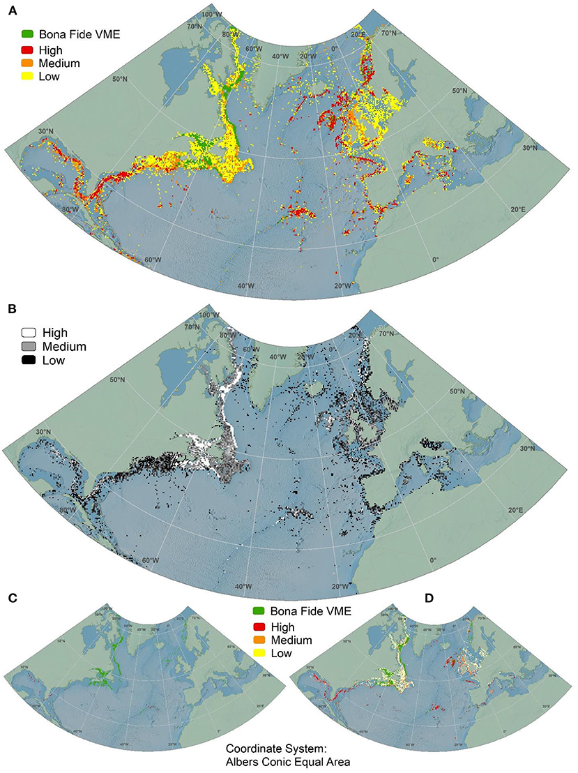
Figure 1. The North Atlantic basin-scale VME and confidence indexes datasets. (A) VME index for all cells with data; (B) Confidence index for all cells with data; (C) VME index for cells with high confidence only; and (D) VME index for cells with medium and high confidence.
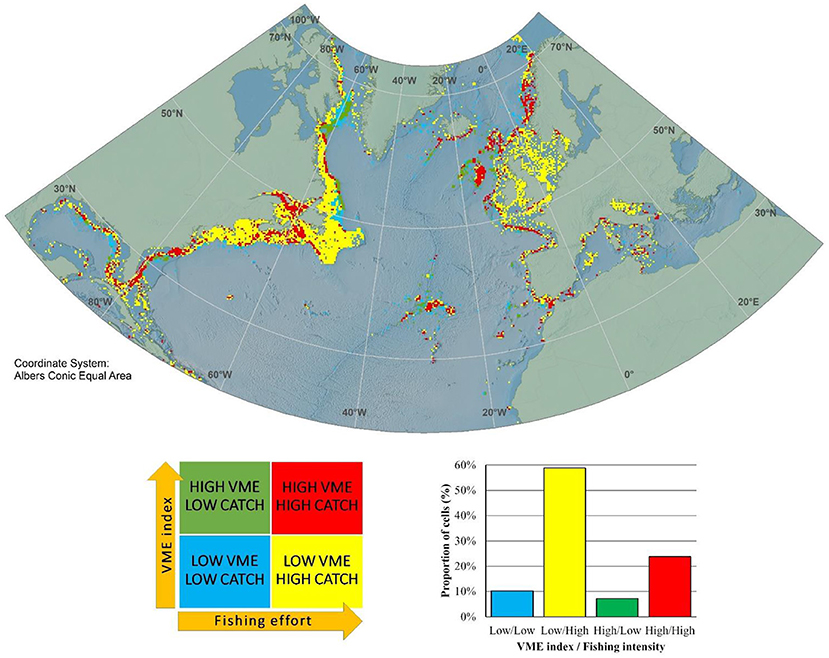
Figure 2. The North Atlantic basin-scale VME index/fishing intensity portfolio dataset. Fishing intensity was adapted from Watson and Tidd (2018). Green cells are high VME index - low catch, red cells are high VME index – high catch, yellow cells are low VME index – high catch, and blue cells are low VME index – low catch. The bottom right panel shows the proportions of cells falling into each portfolio category.
Although we make the North Atlantic basin-scale VME index dataset publicly available for ATLAS partners and other users, the ICES VME database should always be considered as the primary source for the VME index information since it is regularly updated with new information provided by the ICES member countries.
The VME index dataset (Figure 1A; Supplementary Figures 1–5) contained high numbers of VME habitats (bona fide) in the northeastern Canadian coast, the Gulf of Saint Lawrence and the northeastern American coast, which includes the well-known Oculina banks, Lophelia pertusa reefs, Vazella pourtalesii sponge grounds and sea-pen fields. The dataset also reported bona fide VMEs areas around Rockall Bank and along the Norwegian coast, which reflect the presence of large Lophelia pertusa reefs, and which have been extensively sampled. Besides the bona fide VMEs, the dataset also identified other areas with high values of VME index around the Florida-Hatteras slope, the Azores, the Reykjanes Ridge and southern Iceland, around the Strait of Gibraltar, in the Bay of Biscay, the Rockall and Hatton Banks, the Faroe Islands, and along the Norwegian coast. On the other hand, a high number of low VME index areas were found in the North Sea and the English Channel, in the Irish Sea and along the shelves and slopes of the Canadian eastern coast, as well as off the northeastern American coast from the Mid-Atlantic Bight to the Gulf of Maine regions.
The VME index confidence dataset (Figure 1B; Supplementary Figures 1–5) contained mostly VME index values with low or medium confidence, highlighting a limited sampling effort in most areas. With few exceptions, high confidence areas were restricted to bona fide areas (Figures 1B,C) and small areas in the Gulf of Mexico and around Florida, around the Azores and in the Bay of Biscay. The dataset contained medium confidence values inside the Gulf of St. Lawrence, around the Flemish Cap and the Grand Banks, along most of the Canadian coast, as well as around the UK and the Rockall Bank (Figures 1B,D).
The VME index/Fishing intensity portfolio dataset (Figure 2; Supplementary Figure 6) contained high catch values in most of the coastal areas of the North Atlantic, with the exceptions of the central part of the Davis Strait, north of the Flemish Cap, most of the Azores, the Denmark Strait, the southern part of the Reykjanes Ridge, the Hatton Bank and some offshore areas of the Norwegian Sea. The VME index/Fishing intensity portfolio dataset revealed a larger portion of cells categorized as Low VME index–High fishing (59%) and High VME index–High fishing (24%), with only a small portion being categorized as High VME index–Low fishing (7%). The areas where high catch overlaps with high VME index, i.e., areas of potentially significant adverse impacts, are essentially located around Florida and the Hatteras Slope, in the northeast coast of the USA, the Gulf of St. Lawrence and the southern part of the Davis Strait, some around the Azores, the northern part of Reykjanes Ridge and southern Iceland, along the coast of Norway, around the Faroe Islands, Rockall Bank and the margin of the Bay of Biscay and the Strait of Gibraltar. However, the number of cells with high fishing catch should be considered with caution because some catch might have been incorrectly spatially allocated (Watson and Tidd, 2018), highlighting the need to make high-resolution fishing effort maps publicly available.
Data Availability Statement
The datasets presented in this study can be found in online repositories. The names of the repository/repositories and accession number(s) can be found below: http://doi.org/10.5281/zenodo.4279776.
Author Contributions
TMor and CP designed the work and performed the analyses. GT compiled and organized the raw data. TMor, CP, LF, and LR prepared the data report. All authors provided raw data essential for the construction of the dataset.
Funding
This work contributes to the European Union's Horizon 2020 research and innovation program under grant agreement No. 678760 (ATLAS). This output reflects only the authors' views and the European Union cannot be held responsible for any use that may be made of the information contained therein. TMor and MC-S were also supported by the H2020 MERCES (GA No. 689518) project. TMor acknowledges additional support from Program Investigador FCT (IF/01194/2013), IFCT Exploratory Project (IF/01194/2013/CP1199/CT0002) from the Fundação para a Ciência e Tecnologia (POPH and QREN), PO2020 MapGES (Acores-01-0145-FEDER-000056). TMor, CP, LF, CD-C, LR, J-MG-I, GT, and MC-S also acknowledge funds provided by the Fundação para a Ciência e a Tecnologia (FCT) through the plurennial strategic project (UIDB/05634/2020) granted to Okeanos. GT was supported by the Azores Fundo Regional Ciência e Tecnologia (M3.1.a/F/052/2015). GC was supported by the Italian Ministry of Education, University and Research (PON 2014–2020, grant AIM 1807508-1, Linea 1). HE acknowledges funds by the Icelandic Research Fund (174552-052). TNM was funded by the Minobrnauki of RF State assignment No 0128-2021-0008. PD acknowledges funds from the European Maritime and Fisheries Fund within the National Programs of data collection for the EU groundfish surveys in NAFO Regulatory Area. The raw data that made this work possible was obtained from different partners and multiple sources of funding detailed in Morato et al. (2020).
Conflict of Interest
The authors declare that the research was conducted in the absence of any commercial or financial relationships that could be construed as a potential conflict of interest.
Acknowledgments
We would like to acknowledge all of those involved in data collection that allowed the compilation of the ATLAS VME indicators database, namely Javier Urra, Inge van den Beld, Bramley Murton from the Marine E-Tech project, among many others.
Supplementary Material
The Supplementary Material for this article can be found online at: https://www.frontiersin.org/articles/10.3389/fmars.2021.637078/full#supplementary-material
Footnotes
2. ^https://deepseacoraldata.noaa.gov/
3. ^http://www.ices.dk/marine-data/data-portals/Pages/vulnerable-marine-ecosystems.aspx
References
Abad, E., Preciado, I., Serrano, A., and Baro, J. (2007). Demersal and epibenthic assemblages of trawlable grounds in the northern Alboran Sea (western Mediterranean). Sci. Mar. 71, 513–524. doi: 10.3989/scimar.2007.71n3513
Ardron, J. A., Clark, M. R., Penney, A. J., Hourigan, T. F., Rowden, A. A., Dunstan, P. K., et al. (2014). A systematic approach towards the identification and protection of vulnerable marine ecosystems. Mar. Policy 49, 146–154. doi: 10.1016/j.marpol.2013.11.017
Brooke, S. D., Watts, M. W., Heil, A. D., Rhode, M., Mienis, F., Duineveld, G. C. A., et al. (2017). Distributions and habitat associations of deep water corals in Norfolk and Baltimore canyons, Mid-Atlantic Bight, USA. Deep Sea Res. II 137, 131–147. doi: 10.1016/j.dsr2.2016.05.008
Combes, M., Vaz, S., Morato, T., Fauconnet, L., Arnaud-Haond, S., Dominguez-Carrió, C., et al. (2019). Conservation Management Issues in ATLAS. Basin-Scale Systematic Conservation Planning: Identifying Suitable Networks for VMEs Protection. ATLAS Deliverable 3.4. ATLAS Project, p. 119.
Convention on Biological Diversity (CBD) (2008). Decision IX/20 Annex 1. Available online at: http://www.cbd.int/decision/cop/default.shtml?id=11663 (accessed July 10, 2019).
CSA Ocean Sciences Inc,, Ross, S., Brooke, S., Baird, E., Coykendall, E., Davies, A., Demopoulos, A., et al. (2017). Exploration and Research of Mid-Atlantic Deepwater Hard Bottom Habitats and Shipwrecks With Emphasis on Canyons and Coral Communities: Atlantic Deepwater Canyons Study. Vol I. Final Technical Rept., Vol. II: Final Appendices. U.S. Dept. of the Interior, Bureau of Ocean Energy Management, Atlantic OCS Region. OCS Study BOEM 2017-060 (Vol. I) & 061 (Vol. II). 1000 p + appendices.
De la Torriente, A., Serrano, A., Fernández-Salas, L. M., García, M., and Aguilar, R. (2018). Identifying epibenthic habitats on the Seco de los Olivos Seamount: species assemblages and environmental characteristics. Deep Sea Res. Part I Oceanogr. Res. Papers 135, 9–22. doi: 10.1016/j.dsr.2018.03.015
Durán Muñoz, P., Sacau, M., García-Alegre, A., and Román, E. (2020). Cold-water corals and deep-sea sponges by-catch mitigation: dealing with groundfish survey data in the management of the northwest Atlantic Ocean high seas fisheries. Mar. Policy 116:103712. doi: 10.1016/j.marpol.2019.103712
FAO (2009). Report of the Technical Consultation on International Guidelines for the Management of Deep-sea Fisheries in the High Seas, Rome. 4–8 February and 25–29 August 2008. Food and Agriculture Organization of the United Nations Fisheries and Aquaculture Report 881, p. 86.
Hourigan, T. F., Reed, J., Pomponi, S., Ross, S. W., David, A. W., and Harter, S. (2017). “State of deep-Sea coral and sponge ecosystems of the southeast United States,” in: The State of Deep-Sea Coral and Sponge Ecosystems of the United States, eds T. F. Hourigan, P. J. Etnoyer, and S. D. Cairns (Silver Spring, MD: NOAA Technical Memorandum NMFS-OHC-4), p. 60.
ICES (2016a). Report of the Workshop on the Vulnerable Marine Systems Database (WKVME), 10–11 December 2015, Peterborough, UK. ICES CM 2015/ACOM: 62, p. 36.
ICES (2016b). Report of the Joint ICES/NAFO Working Group on Deep-water Ecology (WGDEC), 15–19 February 2016, Copenhagen, Denmark. ICES CM 2016/ACOM: 28, p. 82.
ICES (2018). Report of the ICES/NAFO Joint Working Group on Deep-Water Ecology (WGDEC), 5–9 March 2018, Dartmouth, Nova Scotia, Canada. ICES CM 2018/ACOM: 26, p. 126.
ICES (2019). ICES/NAFO Joint Working Group on Deep-water Ecology (WGDEC). ICES Scientific Reports. 1:56, p. 119.
ICES (2020). ICES/NAFO Joint Working Group on Deep-water Ecology (WGDEC). ICES Scientific Reports. 2:62, p. 171.
Kazanidis, G., Vad, J., Henry, L-A., Neat, F., Berx, B., Georgoulas, K., et al. (2019). Distribution of deep-sea sponge aggregations in an area of multisectoral activities and changing oceanic conditions. Front. Mar. Sci. 6:163. doi: 10.3389/fmars.2019.00163
Kenchington, E., Beazley, L., Lirette, C., Murillo-Perez, J., Guijarro-Sabaniel, J., Wareham, V., et al. (2018a). “Delineation of Coral and Sponge Significant Benthic Areas in Eastern Canada Using Kernel Density Analyses and Species Distribution Models”, Mendeley Data, v1. doi: 10.17632/hnp4xr2sy3.1
Kenchington, E., Murillo, F. J., Lirette, C., Sacau, M., Koen-Alonso, M., Kenny, A., et al. (2014). Kernel density surface modelling as a means to identify significant concentrations of vulnerable marine ecosystem indicators. PLoS ONE 9:e109365. doi: 10.1371/journal.pone.0109365
Kenchington, E., Yashayaev, I., Tendal, O. S., and Jørgensbye, H. (2017). Water mass characteristics and associated fauna of a recently discovered Lophelia pertusa (Scleractinia: Anthozoa) reef in Greenlandic waters. Polar Biol. 40, 321–337. doi: 10.1007/s00300-016-1957-3
Kenchington, E., Lirette, C., Murillo-Perez, J., Beazley, L., Guijarro-Sabaniel, J., Wareham, V., et al. (2018b). Kernel Density Analyses of Coral and Sponge Catches From Research Vessel Survey Data for Use in Identification of Significant Benthic Areas. Mendeley. doi: 10.17632/dtk86rjm86.1
Morato, T., González-Irusta, J. M., Dominguez-Carrió, C., Wei, C. L., Davies, A., Sweetman, A. K., et al. (2020). Climate-induced changes in the suitable habitat of cold-water corals and commercially important deep-sea fishes in the North Atlantic. Global Change Biol. 26, 2181–2202. doi: 10.1111/gcb.14996
Morato, T., Pham, C. K., Pinto, C., Golding, N., Ardron, J. A., Durán Muñoz, P., et al. (2018). A multi criteria assessment method for identifying vulnerable marine ecosystems in the North-East Atlantic. Front. Mar. Sci. 5:460. doi: 10.3389/fmars.2018.00460
NAFO (2016). Report of the Scientific Council Meeting Northwest Atlantic Fisheries Organization. 03−16 June 2016. Halifax, Canada. Serial No. N6587. NAFO Scientific Council Summary Document 16-14 Rev.
Ramiro-Sánchez, B., González-Irusta, J. M., Henry, L.-A. H., Cleland, J., Yeo, I., Xavier, J. R., et al. (2019). Characterization and mapping of a deep-sea sponge ground on the Tropic Seamount (Northeast tropical Atlantic): implications for spatial management in the High Seas. Front. Mar. Sci. 6:278. doi: 10.3389/fmars.2019.00278
Ramiro-Sánchez, B., Henry, L.-A., Morato, T., Taranto, G., Cleland, J., Carreiro-Silva, M., et al. (2020). Compilation of Records of Vulnerable Marine Ecosystem Indicator Taxa in the North Atlantic. PANGAEA.
Rengstorf, AM., Yesson, C., Brown, C., and Grehan, AJ. (2013). High-resolution habitat suitability modelling can improve conservation of vulnerable marine ecosystems in the deep sea (Appendix S1: Sources for distribution data (occurrence records) of Lophelia pertusa for the Irish continental margin). J. Biogeogr. 40, 1702–1714, doi: 10.1111/jbi.12123
Rueda, J. L., González-Garcia, E., Krutzky, C., Lopéz-Rodríguez, F. J., Bruque, G., Lopéz-González, N., et al. (2016). From chemosynthesis-based communities to cold-water corals: vulnerable deep-sea habitats of the Gulf of Cádiz. Mar. Biodiv. 46, 473–482. doi: 10.1007/s12526-015-0366-0
United Nations General Assembly (UNGA) (2006). Sustainable Fisheries, Including Through the 1995 Agreement for the Implementation of the Provisions of the United Nations Convention on the Law of the Sea of 10 December 1982 Relating to the Conservation and Management of Straddling Fish Stocks and Highly Migratory Fish Stocks, and Related Instruments. General Assembly Resolution 61/105, 2006; A/RES/61/105.
Van den Beld, I. M.J., Bourillet, J.-F., Arnaud-Haond, S., de Chambure, L., Davies, J. S., Guillaumont, B., et al. (2017). Cold-water coral habitats in submarine canyons of the Bay of Biscay. Front. Mar. Sci. 4:118. doi: 10.3389/fmars.2017.00118
Keywords: deep-sea, deep-sea fisheries, marine protected areas, area-based management tools, sponges, cold-water corals, vulnerable marine ecosystems, ecologically or biologically significant marine areas
Citation: Morato T, Pham CK, Fauconnet L, Taranto GH, Chimienti G, Cordes E, Dominguez-Carrió C, Durán Muñoz P, Egilsdottir H, González-Irusta J-M, Grehan A, Hebbeln D, Henry L-A, Kazanidis G, Kenchington E, Menot L, Molodtsova TN, Orejas C, Ramiro-Sánchez B, Ramos M, Roberts JM, Rodrigues L, Ross SW, Rueda JL, Sacau M, Stirling D and Carreiro-Silva M (2021) North Atlantic Basin-Scale Multi-Criteria Assessment Database to Inform Effective Management and Protection of Vulnerable Marine Ecosystems. Front. Mar. Sci. 8:637078. doi: 10.3389/fmars.2021.637078
Received: 02 December 2020; Accepted: 01 March 2021;
Published: 23 March 2021.
Edited by:
Pedro A. Ribeiro, University of Bergen, NorwayReviewed by:
Sergi Taboada, Autonomous University of Madrid, SpainFrancis Neat, World Maritime University, Sweden
Copyright © 2021 Morato, Pham, Fauconnet, Taranto, Chimienti, Cordes, Dominguez-Carrió, Durán Muñoz, Egilsdottir, González-Irusta, Grehan, Hebbeln, Henry, Kazanidis, Kenchington, Menot, Molodtsova, Orejas, Ramiro-Sánchez, Ramos, Roberts, Rodrigues, Ross, Rueda, Sacau, Stirling and Carreiro-Silva. This is an open-access article distributed under the terms of the Creative Commons Attribution License (CC BY). The use, distribution or reproduction in other forums is permitted, provided the original author(s) and the copyright owner(s) are credited and that the original publication in this journal is cited, in accordance with accepted academic practice. No use, distribution or reproduction is permitted which does not comply with these terms.
*Correspondence: Telmo Morato, t.morato@gmail.com